

Hi all, Dublin resident here, trying to figure out some data related to car pollution. I stumbled across this google study: https://insights.sustainability.google/labs/airquality?hl=en-US which purports to map out the air pollution in a few cities in great detail (hyperlocal, street-by-street, air quality data). Remarkably, Dublin seems to come out on top. This is flabbergasting to me, a resident of this car riddled city. I am especially surprised that the average Nitrogen Dioxide levels in Dublin seems to be about half that of Amsterdam (in my mind, a cycling utopia). What am I missing here? I can see that the data from Amsterdam is pre-pandemic and the Dublin data is post-pandemic. Is that the major difference? I can also see the Amsterdam data seems to contain a ring road (or two) whereas the Dublin data is missing the M50. To be honest, I am surprised that the Dutch levels are high at all (even in 2019) , I found some info on the modal share of Amsterdam from 2018 that suggested only 20% use private cars with the rest cycling/walking or using public transport (https://www2.deloitte.com/content/dam/insights/us/articles/4331_Deloitte-City-Mobility-Index/city-mobility-index_AMSTERDAM_FINAL.pdf). Any insights welcome!
Ireland is right there on the Atlantic, with big blustery winds flowing over it. Amsterdam doesn’t have this privilege and has pollution from Europe and the uk blow onto it.
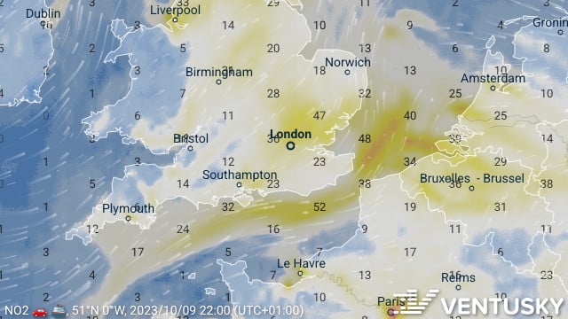 https://www.ventusky.com/?p=51.3;-0.3;5&l=no2&t=20231009/21
Very good point. I noticed London data was also included in that study and seemed to have very high levels of nitrogen dioxide wherever they measured (despite having an excellent public transport system!). That’s a horrible shame that the Dutch have to suffer other nations’ pollution :-(
Enough pol of their own (Rotterdam port, Tata Steel factory, etc.).
Rotterdam does seem to be the major source of pollution - is that one of the reasons why people cycle less there than other Dutch cities?
To be Frank, I do not know. I live onvthe other end of the country.
Found another pollution comparison of Dublin and Amsterdam, which suggests when you take into account a more holistic picture of pollution that Amsterdam is superior: https://www.numbeo.com/pollution/compare_cities.jsp?country1=Netherlands&country2=Ireland&city1=Amsterdam&city2=Dublin