
![[Aug 27] Update: Tropical Storm Idalia (AL10) is predicted to be a Cat 2 hurricane](https://lemmy.world/pictrs/image/18a4f319-8489-4805-96f4-05ad72dd0c30.png)
Idalia’s maximum intensity forecast has been raised slightly to a Cat 2 with predicted sustained winds of 100 mph (85 kts). The forecaster noted that the intensity forecast is somewhat challenging for this storm. See “Discussion Number 5” in the comments for details.
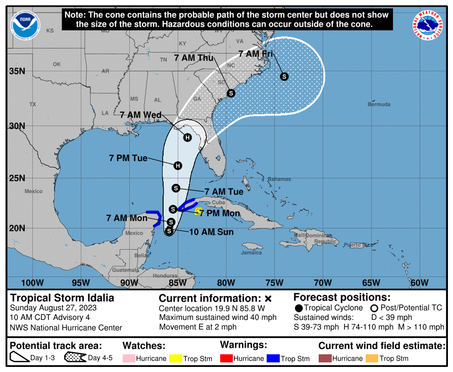
FORECAST POSITIONS AND MAX WINDS
INIT  27/2100Z 20.1N  85.5W   35 KT  40 MPH
 12H  28/0600Z 20.5N  85.3W   45 KT  50 MPH
 24H  28/1800Z 21.7N  85.0W   55 KT  65 MPH
 36H  29/0600Z 23.4N  84.9W   65 KT  75 MPH
 48H  29/1800Z 25.6N  84.5W   75 KT  85 MPH
 60H  30/0600Z 28.7N  83.7W   85 KT 100 MPH
 72H  30/1800Z 31.3N  81.9W   50 KT  60 MPH...INLAND
 96H  31/1800Z 34.5N  76.0W   50 KT  60 MPH...OVER WATER
120H  01/1800Z 35.0N  71.0W   55 KT  65 MPH
Original Post:
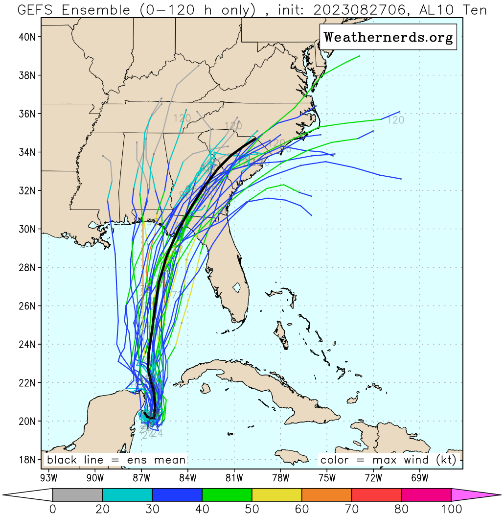
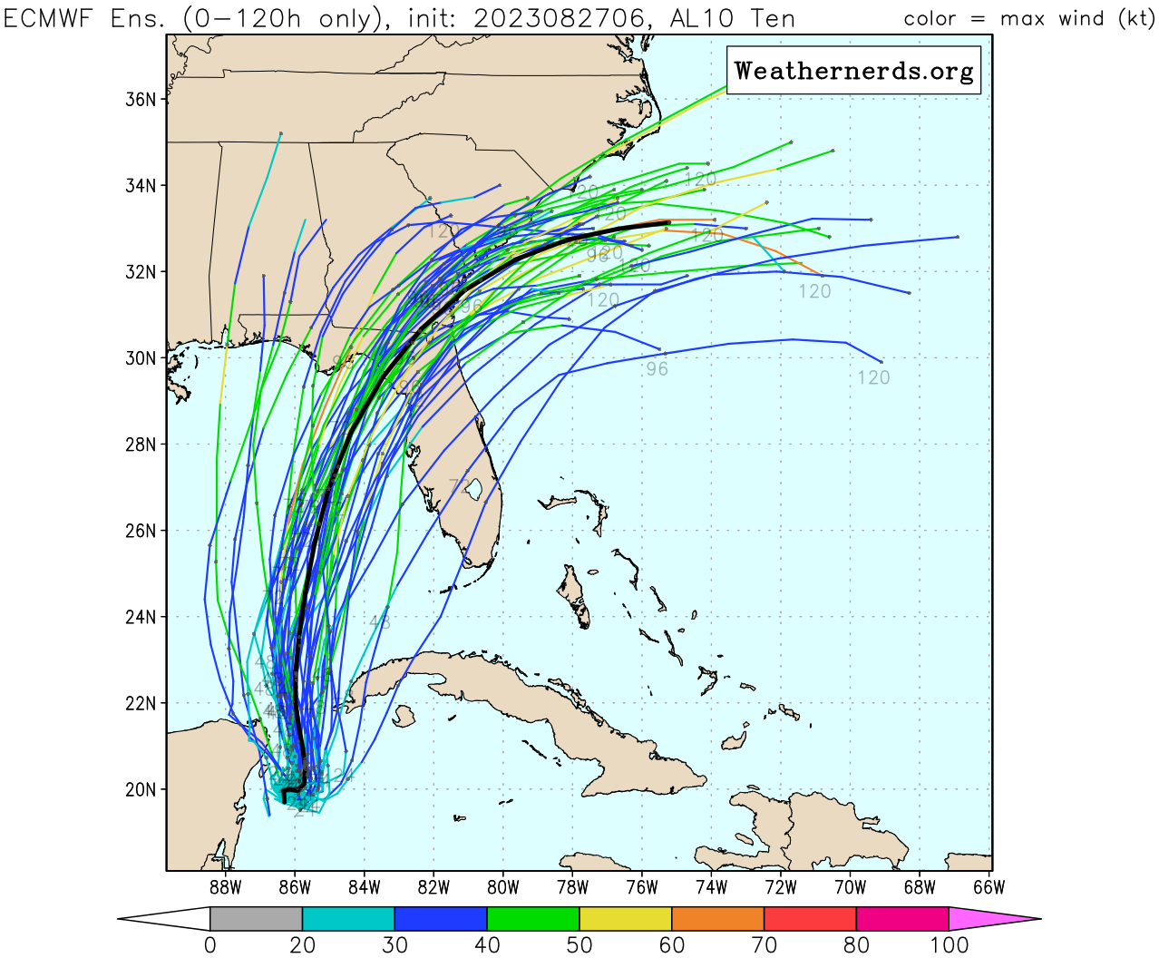
Current predictions from the National Hurricane Center have Tropical Storm Idalia (previously Tropical Depression 10) developing into a Cat 1 hurricane by Tuesday (the next 48 to 72 hours). It’s expected to make landfall in Florida by Wednesday. The official forecast line has it hitting somewhere between Panama City (panhandle) and Tampa Bay (peninsula). The GFS and ECMWF models are mostly predicting landfall around Apalachee bay. These predictions, both the storm track and intensity, may change as the storm develops. When the storm enters the Gulf of Mexico on early Tuesday there will be very warm waters conducive to development, but it will also be under heavy windshear.
FORECAST POSITIONS AND MAX WINDS
INIT  27/0900Z 20.1N  86.8W   30 KT  35 MPH
 12H  27/1800Z 20.1N  86.5W   40 KT  45 MPH
 24H  28/0600Z 20.6N  86.3W   45 KT  50 MPH
 36H  28/1800Z 21.7N  86.3W   50 KT  60 MPH
 48H  29/0600Z 23.3N  86.2W   60 KT  70 MPH
 60H  29/1800Z 25.7N  85.7W   75 KT  85 MPH
 72H  30/0600Z 28.5N  84.7W   80 KT  90 MPH
 96H  31/0600Z 33.0N  81.2W   45 KT  50 MPH...INLAND
120H  01/0600Z 35.0N  75.5W   35 KT  40 MPH...OVER WATER
Resources
- Tropical Storm Idalia - NHC
- CIMSS Tropical Cyclones Group
- Ensemble Forecasts for AL10 - Weather Nerds
Public Advisory
000
WTNT35 KNHC 271459
TCPAT5
BULLETIN
Tropical Depression Ten Advisory Number 4
NWS National Hurricane Center Miami FL AL102023
1000 AM CDT Sun Aug 27 2023
…DEPRESSION COULD BECOME A TROPICAL STORM AT ANY TIME…
…EXPECTED TO STRENGTHEN INTO A HURRICANE OVER THE EASTERN GULF OF MEXICO…
SUMMARY OF 1000 AM CDT…1500 UTC…INFORMATION
LOCATION…19.9N 85.8W
ABOUT 80 MI…135 KM ESE OF COZUMEL MEXICO
MAXIMUM SUSTAINED WINDS…35 MPH…55 KM/H
PRESENT MOVEMENT…E OR 90 DEGREES AT 2 MPH…4 KM/H
MINIMUM CENTRAL PRESSURE…1001 MB…29.56 INCHES
WATCHES AND WARNINGS
CHANGES WITH THIS ADVISORY:
None.
SUMMARY OF WATCHES AND WARNINGS IN EFFECT:
A Tropical Storm Warning is in effect for…
A Tropical Storm Watch is in effect for…
A Tropical Storm Warning means that tropical storm conditions are expected somewhere within the warning area.
A Tropical Storm Watch means that tropical storm conditions are possible within the watch area.
Interests in Florida should monitor the progress of this system. Storm surge and wind watches for portions of the Florida west coast will likely be required later today.
For storm information specific to your area, please monitor products issued by your national meteorological service.
DISCUSSION AND OUTLOOK
At 1000 AM CDT (1500 UTC), the center of Tropical Depression Ten was located near latitude 19.9 North, longitude 85.8 West. The depression is moving toward the east near 2 mph (4 km/h), and it is likely to meander near the Yucatan Channel through tonight.
A faster motion toward the north is expected on Monday, bringing the system over the eastern Gulf of Mexico.
Maximum sustained winds are near 35 mph (55 km/h) with higher gusts. The depression is expected to become a tropical storm today, and strengthen into a hurricane by Tuesday.
The estimated minimum central pressure is 1001 mb (29.56 inches).
HAZARDS AFFECTING LAND
Key messages for this system can be found in the Tropical Cyclone Discussion under AWIPS header MIATCDAT5 and WMO header WTNT45 KNHC.
RAINFALL: The system is expected to produce the following rainfall amounts:
Portions of the eastern Yucatan: 2 to 4 inches, with isolated higher totals of 6 inches.
Western Cuba: 3 to 6 inches, with isolated higher totals of 10 inches.
Portions of the west coast of Florida, the Florida Panhandle, and southern Georgia: From Tuesday into Wednesday, 3 to 6 inches, with isolated higher totals of 10 inches.
Heavy rainfall is also likely to spread into portions of the Carolinas by Wednesday into Thursday.
This rainfall may lead to flash and urban flooding, and landslides across western Cuba. Scattered flash and urban flooding can also be expected across portions of the west coast of Florida, the Florida Panhandle and portions of the Southeast U.S. by Tuesday into Thursday.
WIND: Tropical storm conditions are expected over portions of the warning area over the Yucatan Peninsula today and western Cuba tonight or Monday. Tropical storm conditions are possible within the watch area on the Isle of Youth tonight or Monday.
STORM SURGE: Minor coastal flooding is expected within the Tropical Storm Warning area over the Yucatan Peninsula in areas of onshore winds.
NEXT ADVISORY
Next intermediate advisory at 100 PM CDT.
Next complete advisory at 400 PM CDT. \
$$
Forecaster Pasch
000
WTNT35 KNHC 271155
TCPAT5
BULLETIN
Tropical Depression Ten Intermediate Advisory Number 3A
NWS National Hurricane Center Miami FL AL102023
700 AM CDT Sun Aug 27 2023
…DEPRESSION NEARING TROPICAL STORM INTENSITY…
…EXPECTED TO STRENGTHEN INTO A HURRICANE OVER THE EASTERN GULF OF
MEXICO IN A COUPLE OF DAYS…
SUMMARY OF 700 AM CDT…1200 UTC…INFORMATION
LOCATION…19.7N 86.3W
ABOUT 70 MI…110 KM SE OF COZUMEL MEXICO
MAXIMUM SUSTAINED WINDS…35 MPH…55 KM/H
PRESENT MOVEMENT…SE OR 135 DEGREES AT 5 MPH…7 KM/H
MINIMUM CENTRAL PRESSURE…1001 MB…29.56 INCHES
WATCHES AND WARNINGS
CHANGES WITH THIS ADVISORY:
None.
SUMMARY OF WATCHES AND WARNINGS IN EFFECT:
A Tropical Storm Warning is in effect for…
A Tropical Storm Watch is in effect for…
A Tropical Storm Warning means that tropical storm conditions are expected somewhere within the warning area.
A Tropical Storm Watch means that tropical storm conditions are possible within the watch area.
Interests in Florida should monitor the progress of this system.
For storm information specific to your area, please monitor products issued by your national meteorological service.
DISCUSSION AND OUTLOOK
At 700 AM CDT (1200 UTC), the center of Tropical Depression Ten was located near latitude 19.7 North, longitude 86.3 West. The depression is moving toward the southeast near 5 mph (7 km/h), and it is likely to meander near the Yucatan Channel through early Monday. A faster motion toward the north or north-northeast is expected later on Monday, bringing the system over the eastern Gulf of Mexico.
Maximum sustained winds are near 35 mph (55 km/h) with higher gusts. The depression is expected to become a tropical storm later today and a hurricane by Tuesday.
The estimated minimum central pressure is 1001 mb (29.56 inches).
HAZARDS AFFECTING LAND
Key messages for Tropical Depression Ten can be found in the Tropical Cyclone Discussion under AWIPS header MIATCDAT5 and WMO header WTNT45 KNHC.
RAINFALL: Tropical Depression Ten is expected to produce the following rainfall amounts:
Portions of the eastern Yucatan: 2 to 4 inches, with isolated higher totals of 6 inches.
Western Cuba: 3 to 6 inches, with isolated higher totals of 10 inches.
Portions of the west coast of Florida, the Florida Panhandle, and southern Georgia: From Tuesday into Wednesday, 3 to 6 inches, with isolated higher totals of 10 inches.
Heavy rainfall is also likely to spread into portions of the Carolinas by Wednesday into Thursday.
This rainfall may lead to flash and urban flooding, and landslides across western Cuba. Scattered flash and urban flooding can also be expected across portions of the west coast of Florida, the Florida Panhandle and portions of the Southeast U.S. by Tuesday into Thursday.
WIND: Tropical storm conditions are expected over portions of the warning area over the Yucatan Peninsula today and western Cuba tonight or Monday. Tropical storm conditions are possible within the watch area on the Isle of Youth tonight or Monday.
STORM SURGE: Minor coastal flooding is expected within the Tropical Storm Warning area over the Yucatan Peninsula in areas of onshore winds.
NEXT ADVISORY
Next complete advisory at 1000 AM CDT.
$$
Forecaster Pasch