
Used GPS on boats as early as the late 1980’s, back when selective availability was still a thing. For those unfamiliar with it, GPS was initially military-only, and when they allowed civilian use they were concerned that US adversaries could use it for precision attacks. So SA was included in the civilian version, which introduced a random error of up to something like 1000 yards.
The truly ironic thing is that the US Coast Guard (a branch of the very military that created SA) saw the usefulness of GPS for marine navigation, but only if SA was removed. 1000 yards could easily mean the difference between a boat running aground (or worse) or not.
So the USCG built ground stations that would receive GPS signals, calculate the SA error, and broadcast a fixed signal. That was called Differential GPS, or DGPS. Boaters could buy special DGPS receivers for years, which were as accurate as GPS without the SA error.
Eventually the military was convinced to do away with SA entirely so DGPS was retired. It was only after that happened that GPS became globally useful for car, hiking, etc. navigation.
Yes, palm pilot or whatever that thing was called. It worked pretty well.
Yup, was a Garmin. Part of me has been a little worried cause i can’t find my way anywhere without GPS anymore, and Google has been getting shittier every day.
Hell, I remember the first time I used maps on a computer to plan and print a route, and the first time I could do it online with MapQuest.
Those were moments that the Internet really felt like the future.
I’m still not sure how i found anything before gps was a thing. I remember getting my licence and my first trip with a friend. He printed out like 20 pages of google maps. He sat next to me and went through it like a person wo went mad on the nautilus. Halfway through it, he threw it all on the backseat and only kept the last page and said: "we’re looking for some place that sounds like hitler and then 15 min later we go left and there is a house with a dragon in the yard.
We never took a wrong turn on the whole trip. Same at work, i would get a bad printout of a city block where i wasn’t even sure where it was. And somehow after driving around in circles for a bit i would always magically find it.
I used to tape maps to the gas tank of my motorcycle on trips.
Then mapquest became useful and I taped printed directions. Made it a lot easier.
Then I got a Garmin waterproof, handlebar mounted GPS and it was glorious, though you had to buy map updates every couple years.
Eventually phones were actually able to be used for directions and I kept a phone connected to a homemade battery pack in my jacket pocket, with an earbud under my helmet, so I just listened to directions and music.
Finally got a phone connected to a handlebar mount, plugged into the bike power, with a Bluetooth headset built into the helmet. Probably the least safe of the options, but I can listen to podcasts, audiobooks, music and see the maps while it directs me with audio, just like a car display would.
I rode from the UK to northern Italy with nothing but an early hiking go’s unit that had no map. Just an arrow pointing to Torino. The trip over the Alps was very random.
Didn’t mapquest get sued for routing people through a dangerous neighborhood? Then they started putting a disclaimer?
It tells you which direction something is in, but can’t help plot a route to get there.
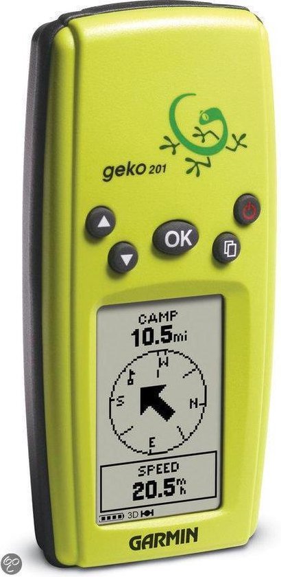
I still use my Garmin Geko even now. Useful as a basic device recording a track I can geocode photos with, and runs for days on two AAA batteries. In a pinch you can reverse a track and go back the way you came too 😅
That’s such a good idea. My camera has to pair with my phone to get GPS readout and it’s a nightmare app. Going to look into this
Nice device!
I remember how tedious using maps to get anywhere was.
Last week I traveled through some rural desert backroads and Apple Maps got me there no problem, but it had taken me on an indirect route. As I was driving I discovered that it was because a number of the roads were completely closed. If I had been using maps I would have had to stop and figure out the detours on my own.
I still remember printing out google maps directions, then missing one turn and then being completely lost.
The number of times I had to stop and recalibrate with the paper map was high!
I used to geocache this way because I couldn’t afford a GPS. Finding caches took some time!
Internal thought process: “psh, it’s not just over-35’s who remember the dawn of GPS, I’m only… thirty… six…” 😩
I don’t have deeply shocking memories about using GPS for the first time, it was just this gadget my dad got for road trips so we didn’t have to deal with an atlas. However, I still remember being a passenger in a moving car using my first smartphone, watching our progress on Google Maps and feeling like I had gained the ability to see around corners. Technological progress seemed unambiguously positive and my phone just kept getting more useful.
Alternate question: do any of you (maybe a bit older than 35) remember the last time you bought an updated paper map for your area, or one for a road trip? They used to be at most checkout lanes in many stores.
I can already hear the “maps on paper? How could you find anything?”
I do still use my city’s paper bike route maps, although they’re free. I rarely use them to get to a specific place, though, just for planning where I can make a contiguous loop I haven’t done before.
Yes, I get paper maps of my area. For hiking, but I think it still counts.
The last time I used a paper map for driving? Probably early aughts
I would guess that hiking or trail maps are probably much more detailed than a road map, so that makes sense that it would still be a thing, although certainly digital versions have made some dent in them. Electronics are a bit more susceptible to the environment and the need for power though, so maybe not as much for those reasons.
Yep, right on. For a day hike or simple trail, I’ll trust my phone maps and Garmin GPS. Anything beyond that, I’m bringing a map and compass as a backup because they don’t require power and the good ones still work even if wet.
Even for a simple day hike, I’ll usually print out a map because it’s quicker than using my phone.
Maybe five years ago?
I like having paper maps in the “oh shit” bag
No, because if I need information I stop at information places at the border and get a map for free. Sometimes you can get whole guidebooks full of maps and directions and interpretive information for free. I picked up maps or guidebooks multiple times this year.
Yep. Seemed pretty shiny compared to printing off directions from MapQuest. Then we figured out how to customize the voice, and it was shenanigans from there.
Man, TomTom had some kickass ones. Vader was on mine for too long.
On my first smart phone ca. 2014, I had Here Maps (a Nokia product I think?). I didn’t have any data plan, and that mapping service didn’t require it. I don’t think I ever used it, but that may be the first. Otherwise, earlier this year I used my work phone and whatever it has for navigation. I hated it 😅 I clearly liked knowing directions more then one turn out.
I couldn’t tell you the specifics, but back in the 1990’s, we had GPS devices that just had an LCD read-out of your latitude and longitude, so you could find your position on a paper map. They were on the market as survey devices, but were also useful for wilderness travelers.
It’s hard to recall exact dates, because the devices developed incrementally, and navigation mode on Google Maps didn’t spring into existence ask at once.
In 2001, I rented a van in Japan. Digital mapping is essential for Japan, because most streets have no names, and house numbering is almost completely random, often based on the year they were built rather than any linear sequence.
It was incredible to me to be able to punch in a destination and see the map. At the time, I don’t think it could speak the directions to you. And you could search for nearby restaurants and gas stations too!
I did pizza delivery for years without GPS.
We had a really early one in the 90s, like way earlier than anyone else we knew, in a car we bought from some rich guy. We only used it once or twice as a novelty as my Dad always insisted he knew better. Plus it had its maps loaded up using some CD which was really out of date and it wasn’t like you could type in McDonalds and it would take you to the closest one, you had to put the whole address in and even then I think it wouldn’t find it half the time.
The first one I got was a gift in the 00s and it was bloody awful. Once I t turned me off a perfectly straight road to drive through a graveyard and then put me back on the road I had been on. Another time it turned me off and sent me down the only toll-road in the UK, then got me off at the first exit and put me back on the toll-road in the opposite direction to get me off at the place I’d got into it earlier. I had to pay twice to go nowhere and it added five minutes to my journey.
Just to add, when people came round our house in the late 90s my Dad would make me turn on the computer to show them MS Autoroute, which was an offline piece of software that was used to generate routes, basically what Google Maps does now with directions, but it would just give you something to print out. Really useful for the day and you could even get it to estimate how much the fuel would cost, etc.
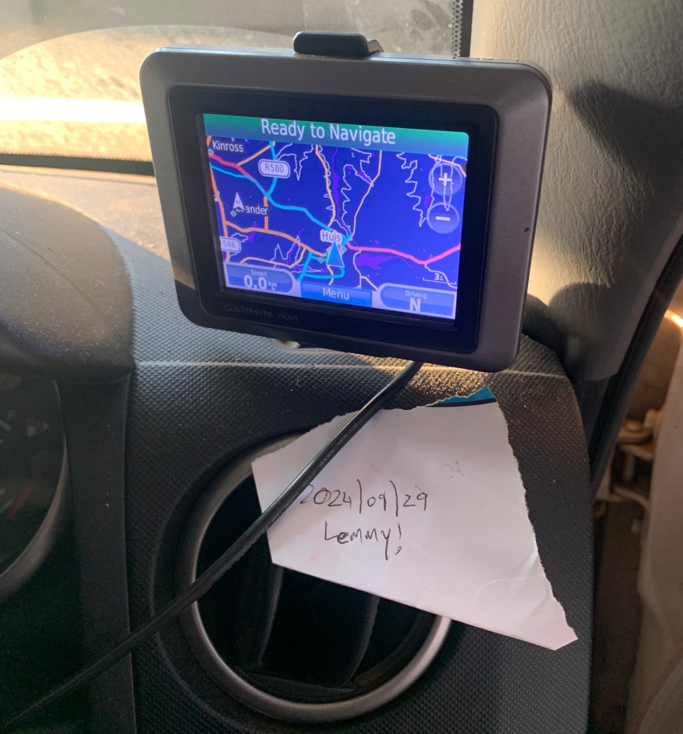
Garmin nuvi 250, and then shortly after that a Garmin Nuvi 500, which I still use almost every day when I drive.
Almost 20 years old.